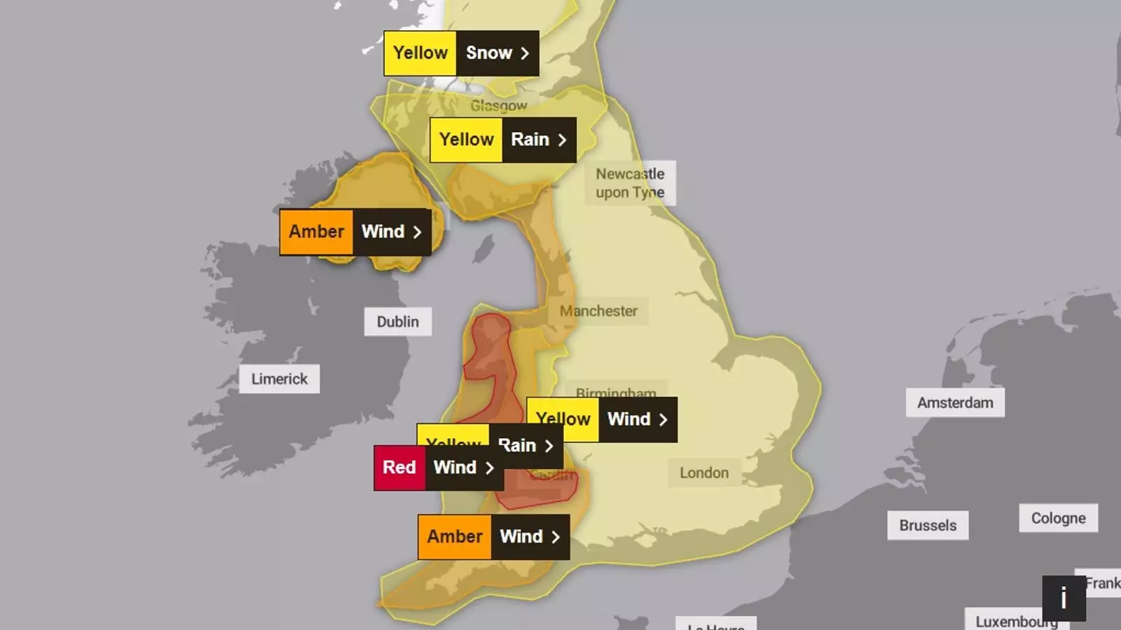
As the UK braces for the impact of Storm Darragh, a severe red wind weather warning has been put into effect, marking an urgent call to action for residents in affected areas. Forecasters expect wind gusts to reach an alarming 90 mph, raising concerns over potential “damaging winds” that could disrupt lives and infrastructure significantly. The Met Office has cautioned that this weather system, which is predicted to gain momentum over the weekend, poses a considerable threat not just to property but to personal safety as well.
This latest storm is not mere meteorological chatter; it could unleash a dangerous cocktail of flying debris, uprooted trees, and other hazardous conditions across parts of Wales and the South West of England. Major cities, including Cardiff, Bristol, and regions in Devon, find themselves at the heart of this impending tempest, with alerts set to remain in effect from the early hours of Saturday.
The classification of weather warnings is crucial for public safety, especially when it comes to red alerts—these are the most severe categories communicated by meteorologists. They signal the seriousness of the situation and underscore the risk of “dangerous weather.” According to the Met Office, individuals in the areas affected must prepare for substantial disruption across transportation, potential power outages, and widespread infrastructural damage. It’s not just theoretical; these warnings translate into real-life risks that can affect communities.
In conjunction with the warnings issued in the UK, the Irish meteorological service, Met Éireann, has declared a similar red alert for coastal regions in Ireland, including counties like Mayo and Galway. This reveals the interconnected nature of weather patterns across the Irish Sea, prompting key authorities to act preemptively.
In addition to fierce winds, Storm Darragh is expected to bring with it a deluge of rain, leading to potential flooding that could further compound the hazards already presented by high winds. Multiple weather advisories are in place for regions in Northern Ireland and parts of central Scotland. The threat of snow adds another layer of complexity; the Met Office has issued warnings specifically for central Scotland, highlighting the potential for severe weather conditions as winter encroaches.
Over the course of Saturday, the forecast suggests that large areas in Wales and Northern Ireland may see significant rainfall, with predictions of up to 90mm. Such volumes of water could overwhelm drainage systems, lead to localized flooding, and create treacherous conditions for travelers.
As the storm progresses, major transportation networks are bracing for disruption. Bus and train services are likely to face delays or cancellations due to unsafe conditions and hazardous roadways accompanied by spray and flooding. With seven flood warnings and numerous alerts in place across the UK, local authorities and emergency services are gearing up for what could be a challenging day.
Communities that recently endured the effects of Storm Bert face the dual burden of recovery while preparing for yet another weather event. This presents a formidable challenge for both individuals and businesses already struggling to cope in the aftermath of prior disruptions.
Preparedness: A Community Effort
In times of severe weather, collective preparedness becomes essential. Communities should remain informed about weather updates and take proactive measures. It is vital for residents in warned areas to secure outdoor belongings, stay indoors during peak storm conditions, and have emergency plans in place. Cooperation between local authorities and the public can mitigate the impacts of such events.
Ultimately, Storm Darragh underlines the formidable power of nature and the limitations of modern safety infrastructures. As residents await the storm’s arrival, it’s a moment of caution and respect for the untamable elements that shape our environment. Awareness and action can make all the difference in navigating the stormy seas ahead.


Leave a Reply